S/V Sleipnir – off Shilshole
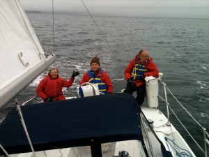
Mike & Margaret & Ceese & Jenna
Windworks at Shilshole
S/V Sleipnir – Dufour 325
Winds: S@10-20 with occasional gusts to 30
Amanda very graciously offered us the use of the beautiful Dufour 325 “Sleipnir” for today’s sail. Â Thank you Amanda!
At 9am NOAA forecast winds increasing later to S@15-25, while Popcorn forecast gusts to 40 based on computer models.
 Sleipnir was in a tight berth inside Tehanu. Â I was in two minds as to whether she would fit through the gap and would certainly never have attempted it without the approval and kind assistance of Popcorn. Â In the event Sleipnir threaded the needle with a foot or two to spare, and Popcorn then moved Tehanu forward which greatly eased our return.
After leaving dock at 10:50 we motored out the south entrance and made sail, single-reefed and with much reduced jib and plenty of twist in case of gusts. Â In order to avoid crab-pots we didn’t stop the motor until just past the south mooring buoy, where a large eagle was perched. Â Our intention was to round West Point and sail in Elliott Bay. However winds increased sharply as we approached West Point so we tacked 180 to a broad reach toward Meadow Point and eventually as far as Pipers Creek in Carkeek Park. Â We then started tacking south, staying mostly east of the shipping lanes, until we came to West Point buoy, where we turned again, reached to Shilshole safe water mark, dowsed sails, and motored back to dock.
 For the most part seas were running 1′ and occasionally 2′. However about a quarter mile west of West Point a distinct line in the sea distinguished waves which fetched only from Alki Point from those waves which fetched from the South Sound. Â On our last tack before our final approach to West Point we ventured across this line for about a quarter mile. The seas there were 4′ and short and not easy to steer in.
What then of distance run and winds encountered? Â Unfortunately I had forgotten to start my GPS recorder at the dock. Â Sleipnir has both a measure of distance through water and an anemometer but all boat instruments should be viewed with some scepticism.
 Sleipnir recorded 13.11nm distance through water. Â Due to much reduced sail, indicated speeds were mostly 2.5kts occasionally reaching 5kts. Â Currents would have been light, peaking at about 0.5kts setting north on our final approach to West Point. Â Based on a comparison of a partial GPS track and GPS speed samples with
Sleipnir’s measurements, and based on the distance covered over ground, I estimate we ran about 15nm. Â We were under way 4h40m, therefore averaging 3.2kts.
Sleipnir mostly indicated wind speeds from 10 to 20kts (true). The highest gust that we noticed on Sleipnir’s gauge was 28.5kts (true). Â These speeds are broadly in agreement with wind speeds observed by ferries and the 520 bridge, after allowing for our slightly sheltered locations.
 And what of the 40kt gusts forecast by Popcorn? Â Well the 520 bridge had a gust of 41mph at 3:40 just after we docked, followed by gusts of 45 and 46mph. Â Popcorn’s advisory was excellent.
We didn’t sail far and we didn’t sail fast today but we had a fine time and practiced sailing skills and returned safe. Both Jenna and Ceese are expanding their helm and sail handling skills to these larger boats, while Ceese has a keen interest in navigation and is fast learning techniques in that area too.
Images courtesy of Margaret.
Recent Comments